Photos of ‘incomplete’ streets — those built with speeding cars in mind and little thought to people traveling by any other mean — have been vital in explaining the necessity of Complete Streets policies across the country.
Capturing the anger and frustration many felt after learning about Raquel Nelson — the single mom in Atlanta charged with vehicular homicide when her son was killed while crossing an unsafe street with her — our partners at Transportation for America have launched an initiative to show just how common these dangerous streets really are.
Help us continue to tell the story of ‘incomplete’ streets. We want to share your photos, of your communities, with Congress and transportation officials and feature them in blog posts and publications (with your permission, of course).
Show the country’s decision makers what it looks like out there for people trying to walk, bike, and ride public transportation: the missing crosswalks; the inaccessible curbs; the 1/2-mile treks to the nearest crosswalk along a 50 mph highway; the transit stops that are patches of mud and a pole; and dangerous roads designed for speeding traffic rather than safe walking or bicycling.
Here’s how to send your photos — or video! — of America’s dangerous, incomplete streets:
- Email: You can email photos to us at [email protected]. When you send them, please let us know if we can upload these to our Flickr account (with your credit information in caption like this one). Anywhere we use your photos, we’ll always give you credit.
- Flickr: Add photos to the T4 America Flickr group, and tag them with “dangerous by design” so we’re sure to see them. If you have photos but don’t want to add them to the group, you can just add the tag “dangerous by design”. We always prefer photos licensed with Creative Commons, so we can use these photos in meetings with Congress or on the blog with credit given to the source.
- Video: You can upload videos directly to T4’s Facebook page, but YouTube or other video sharing sites are fine. Send us a link. If you send in videos directly to the email address, they need to be under 10 MB.
- If you’ve got another way to show us your photos other than these, drop us a line at [email protected]
Check out a few of the photos submitted so far:
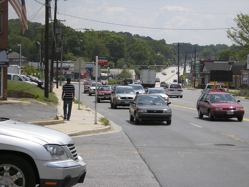 |
| Bladensburg-22 Originally uploaded by wtrecat to Flickr. |
| MD 450 just west of junction with MD 202. Very busy road with no pedestrian crossing at this spot across from El Primo international market, 5403 Annapolis Rd. |
Note that this photo from Maryland just outside D.C. is taken at a Metro bus stop. And there appears to be no safe crossing immediately nearby.
 |
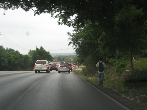
| Incomplete Street Originally uploaded by Boenau to Flickr. |
| No sidewalks? No problem! |
There’s no sidewalk at all along this road. And the overgrowth forces anyone trying to walk out into the roadway. If there is a crosswalk at the light up ahead, pedestrians have to cross at least 8 lanes of traffic and a median to make it across.
 |
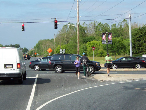
| Incomplete Street Originally uploaded by Boenau to Flickr. |
| As if walking on the goat path isn’t bad enough, rainfall drains and collects on the grass, forcing pedestrians into the street. |
Just because there aren’t any sidewalks doesn’t mean that people won’t or aren’t walking. It has to be terrifying to walk on this narrow strip of grass next to 3 straight lanes of high speed traffic. And once again, if there is a crosswalk 200-400 yards down behind this pedestrian, people on foot will have to cross at least 6 lanes of traffic and a median in one light cycle.
 |
| elkton_rd3 Originally uploaded by Transportation for America to Flickr. |
| Submitted photo by Frank Warnock of Bike Delaware. www.bikede.org/ (Please credit photographer, not T4 America.) |
Smooth, graduated turning radii like this are especially dangerous to pedestrians. Turns are engineered like this so traffic can make a right turn while only having to barely slow their speed, making it extremely hazardous for people on foot to cross from the island back to the side of the road.
 |
| IMG_6603 Originally uploaded by Transportation for America to Flickr. |
| Bee Caves Rd/RM 2244 west of Walsh Tarlton Lane in Austin, Texas. Roadway under TxDOT jurisdiction. Submitted photo by Joan Hudson, P.E., of the Texas Transportation Institute. (Please credit photographer, not T4 America.) |
The photos we got from this supporter in Texas were all taken on roads managed by the Texas DOT. Pedestrians here have to walk in a ditch with nowhere to escape to if a car veers slightly out of the lane.