


News
By Colin Murphy, October 31, 2013
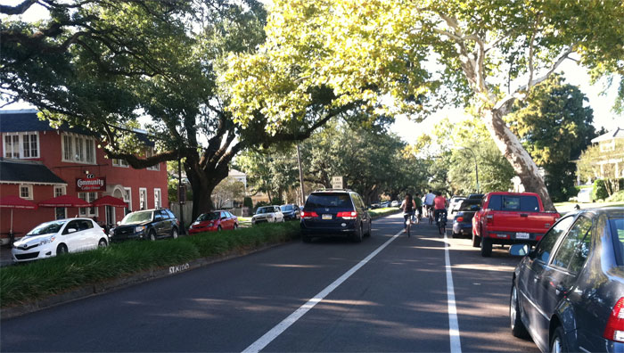
Esplanade Avenue in New Orleans after Complete Streets improvements. Photo by Jennifer Ruley.
With one of the best Complete Streets policies in the nation and champions for multimodal transportation on the City Council and public agencies, New Orleans, LA is taking concrete steps to build a post-Katrina transportation network that's safer, more equitable and more fully connected than before.
The city's most recent addition to its list of accomplishments is its new Complete Streets Advisory Committee. This month the City finalized the membership of the new Committee, which will make sure public agencies and processes work together to create a transportation system that works for all residents, no matter how they get around.
Creating a Complete Streets Advisory Committee was one of the steps laid out by New Orleans' Complete Streets ordinance, passed in 2011. City leaders recognized an opportunity to make streets safer and more convenient as they rebuilt after Katrina, and the Complete Streets ordinance formalized that commitment. Among the ordinance's many champions was City Councilmember Kristin Gisleson Palmer, who is now also a member of Smart Growth America's Local Leaders Council.
The new ordinance reinforced changes that were already taking place in some city departments, and in March 2012 Smart Growth America's National Complete Streets Coalition facilitated a technical assistance workshop in New Orleans that brought together policymakers and practitioners to make Complete Streets strategies a city-wide approach.
Complete Streets in practice: Esplanade Avenue
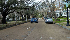
Esplanade Avenue in New Orleans, before the improvements. Photo: Regional Planning Commission.
Esplanade Avenue is one of the projects recently completed under New Orleans' new Complete Streets ordinance.
A 19th-century boulevard running from the Mississippi River to City Park, Esplanade is an important connection within the central city. Roughly 10,000 vehicles per day use the road, and it's also a heavily trafficked route for people walking and on bicycles. As traffic on the road increased over time, planners added travel lanes and parking, but because of the area's historical significance widening the road was never an option. So despite its narrow lanes and frequent intersections, drivers often travel on Esplanade Avenue at high speeds and with aggressive lane changes in a narrow right-of-way.
As a result, Esplanade is among the city's most hazardous streets for people walking and on bicycles. "Esplanade has repeatedly surfaced in the crash data as a top crash corridor," says University of New Orleans transportation researcher Tara Tolford.
When it came time to resurface Esplanade Avenue the city's Complete Streets policy encouraged engineers to consider how they could make the street better for everyone who uses it. As a result, engineers removed one travel lane in each direction while upgrading sidewalks, ramps and crosswalks as well as painting bike lanes.
Residents say the street is noticeably more comfortable for everyone traveling on it, and the Regional Planning Commission estimates that daily pedestrian traffic on that stretch increased 169% and bicycling traffic 123% between 2010 and 2013 (when traffic was down to one lane each way but the bike lane was only partially complete).
New Orleans still has work to do to perfect its Complete Streets approach. "The process is still a little ad-hoc," says pedestrian and bicycle engineer Jennifer Ruley. "But we're way better at anticipating the kinds of roadways that would get a particular treatment."
With entities like the Complete Streets Advisory Committee becoming a more formal part of the city's work, New Orleans is positioning itself for a post-recovery future when safe, convenient streets are the rule rather than the exception.
Related News


Livable places. Healthy people. Shared prosperity.


© 2026 Smart Growth America. All rights reserved
Site By3Lane Marketing
